top of page

Profile
Join date: Mar 9, 2018
About
7 likes received
0 comments received
0 best answers
Posts (95)
Apr 4, 2025 ∙ 3 min
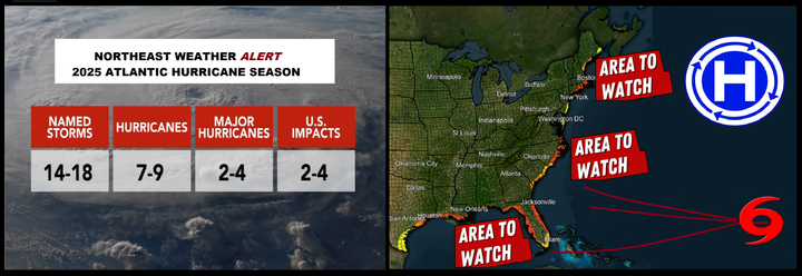
2025 ATLANTIC HURRICANE SEASON OUTLOOK.
The Atlantic is expected to experience an active hurricane season this year, with conditions aligning to enhance the likelihood of...
68
0
2

Mar 28, 2025 ∙ 1 min
Forecast for Potential Ice Storm in Northern New England – March 29, 2025
Overview: A significant weather system is forecast to impact Northern New England on Saturday, March 29, 2025, bringing a mix of sleet,...
131
0
1

Mar 22, 2025 ∙ 1 min
SPRING AND SUMMER ALERTS BEGIN IN APRIL
The Dashboard will soon resume publishing its Spring and Summer weather outlooks, following a similar format as the Fall and Winter...
51
0
bottom of page